What is an airport digital twin?
A digital twin is a 3D model of a real facility that's accurate enough to use for operational purposes. Not a concept render. Not a marketing visualization. A working model that matches the real thing in geometry, position, and proportion so that decisions made using the model apply to the real airport.
In the airport context, a digital twin typically includes the runway and taxiway system, terminal buildings, aprons, navaids, approach lighting, surrounding terrain, and the airspace immediately around the field. The level of detail depends on the use case, but the common thread is accuracy. The model has to be right, not just look right.
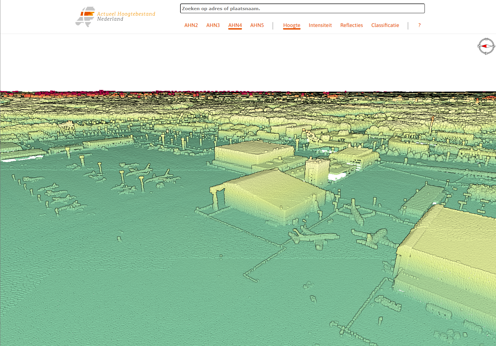
LiDAR point cloud of EHAM Schiphol — the raw 3D data behind a digital twin
Who's using them and for what
Airport digital twins are showing up across several areas of aviation, from flight training to infrastructure planning to safety analysis. The technology isn't new, but it's becoming more accessible as the cost of source data (satellite imagery, LiDAR, aerial survey) comes down and the tools for building and rendering 3D environments improve.
Pilot training
Airlines and training organizations use airport digital twins to build route-specific visual databases. When a pilot can rehearse the visual approach to a new destination before flying it for real, the training value is significant, especially at airports with terrain, complex procedures, or unusual visual references.
Infrastructure planning
Airport operators use 3D models to evaluate proposed construction, test new taxiway configurations, or assess the visual impact of a new building on approach paths. It's faster and cheaper to test changes in a model than to discover problems during construction.
Safety analysis
Obstacle assessment, approach procedure design, and emergency response planning all benefit from an accurate 3D representation of the airport and its surroundings. Digital twins can be used to verify obstacle clearance surfaces and visualize proposed instrument procedures before they're published.
Stakeholder communication
When an airport authority needs to explain a proposed expansion to regulators, airlines, or the public, a digital twin communicates scale and spatial relationships better than 2D drawings or written descriptions. You can show people what it will look like, not just tell them.
What makes a good one
Not all 3D airport models qualify as digital twins. A render that looks impressive in a presentation but doesn't match the actual airport geometry is marketing material, not a working tool. The difference comes down to a few things.
First, the terrain model. The ground the airport sits on has to match published survey data. For airports where approaches interact with terrain, this means using elevation data with enough resolution to reproduce the features that matter for operations. A ridgeline that's 10 meters off will produce incorrect approach visuals and useless obstacle assessments.
Second, positional accuracy. Runways, taxiways, buildings, and navaids have to be in the right place. This sounds obvious, but many 3D models are built from satellite imagery alone, which introduces errors from image alignment, perspective distortion, and temporal differences between image capture dates. Cross-referencing with published airport diagrams, AIP data, and survey coordinates catches these problems.
Third, the level of detail has to match the use case. A digital twin for pilot visual training needs accurate approach lighting, runway markings, and surrounding visual references. A model for infrastructure planning might need detailed terminal interiors or subsurface utilities instead. One size doesn't fit all.
The best digital twins are built for a specific purpose and validated against that purpose. A model that tries to do everything at once usually does nothing particularly well.
What it costs
The cost of an airport digital twin depends on the size of the airport, the level of detail, and the source data available. A small regional airport with one runway and a simple terminal can be modeled for less than a major international hub with multiple terminals, complex taxiway systems, and extensive surrounding terrain.
As a rough guide, regional airports typically fall in the $15,000-$75,000 range for a comprehensive digital twin. Larger facilities with more complex requirements range from $75,000 upward. These numbers assume that some usable source data exists (satellite imagery, existing survey data, AIP documentation). If new aerial surveys or LiDAR captures are needed, that adds to the cost.
The timeline is typically 8-16 weeks from project scoping to delivery, depending on complexity and data availability. Faster timelines are possible for smaller facilities or projects with good existing data. Larger projects may take longer if new surveys are involved.
How the industry is moving
Airport digital twins are becoming more common as regulatory bodies, airlines, and airport operators recognize the value of accurate 3D representations for planning and safety. ICAO has been encouraging the use of digital tools for aerodrome design and obstacle assessment. Airlines are investing in visual databases for their training fleets. Airport operators are finding that 3D models pay for themselves the first time they prevent a design conflict or catch an obstacle clearance issue before construction begins.
The technology is also converging with simulation platforms. A digital twin built for infrastructure planning can often be adapted for pilot training use, and vice versa. That multi-use potential makes the initial investment easier to justify, because the model serves more than one department.
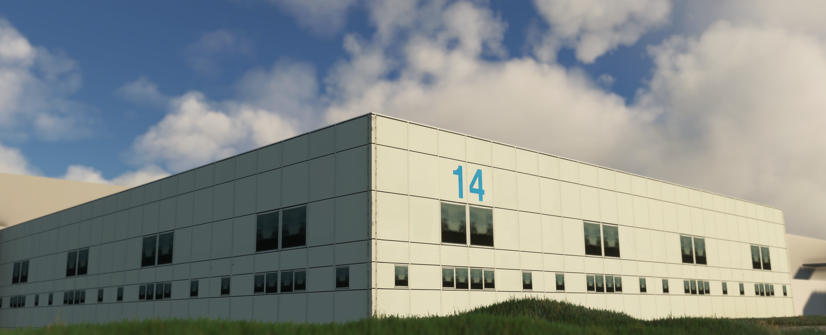
From data to simulation — a finished building in the EHAM digital twin
Where PSSW fits
We come at this from the simulation side. Our background is in building airports for consumer flight simulation platforms, where the end users are knowledgeable, detail-oriented, and quick to notice when something is wrong. That background trained us to build accurately and to validate our work against published data.
We now apply the same pipeline and methodology to B2B projects for airports, training organizations, and aviation authorities. The process is the same: gather data, build to spec, validate against published references, deliver a model that works for the intended purpose. The output format and level of detail adapt to the client's needs.