The airport
GCRR — César Manrique-Lanzarote Airport — serves an island that receives over 7 million passengers a year, mostly European holiday traffic. It sits on the eastern coast of Lanzarote at 14 meters above sea level, with a single runway oriented 03/21 and steady trade winds coming off the Atlantic. For pilots, it's known for crosswinds. For modelers, it's known for lava.
Lanzarote is one of the most volcanically shaped islands in the Canary archipelago. The devastating 1730–1736 Timanfaya eruption cycle covered a quarter of the island in basalt lava flows, and volcanic activity continued into the 19th century. The terrain around the airport — and across most of the island — is a mix of dark volcanic rock, sparse scrubland, and ochre desert. This creates a visual environment unlike anywhere else in the flight simulation market.
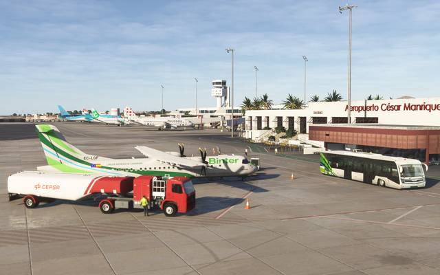
The apron at GCRR with Binter Canarias turboprops and the terminal building
The terrain challenge
Standard elevation data struggles with volcanic terrain. Lava fields are rough, irregular, and full of micro-features — collapsed tubes, pressure ridges, tumuli — that don't show up in 30-meter resolution datasets. From the air, these features are visible and they define the character of the approach. Pilots flying into Lanzarote see a dark, textured landscape that's visually distinct from the lighter areas of sand and cultivation. If the terrain model flattens all of that into a smooth surface, the visual approach doesn't feel right.
We sourced high-resolution elevation data for the entire island and built a custom terrain mesh that preserves the volcanic surface character. The lava fields around the airport retain their visual texture. The caldera profiles on the northern part of the island hold their shape. The coastal cliffs maintain their correct height above the water.
Ground textures on basalt
Lanzarote's ground cover is unusual. Large areas of the island are bare volcanic rock — not the gray granite of most rocky terrain, but dark, almost black basalt with a rough, glassy surface. Other areas are covered in lapilli, small volcanic pebbles that farmers use as mulch in the distinctive zocos vineyards.
None of these surfaces exist in standard texture libraries. We built custom ground textures from satellite imagery and reference photography, creating a material set that captures the albedo and roughness characteristics of the island's volcanic surfaces. The basalt lava fields, the lapilli-covered agricultural areas, the white-painted towns, and the ochre desert flats each have distinct PBR material properties.
The key insight was that Lanzarote's terrain isn't just a color — it's a roughness profile. The dark lava fields absorb light differently from dark asphalt. Basalt scatters light at the micro level due to its vesicular surface texture. Getting this right required calibrating roughness values specifically for volcanic rock, something we hadn't needed at our California airports.
Crosswind operations
GCRR's runway 03/21 runs roughly north-south, and the prevailing trade winds come from the northeast. This means that most landings involve a crosswind component, and strong crosswinds are routine rather than exceptional. During winter, wind speeds regularly exceed 25 knots with gusts above 35.
For training purposes, the accuracy of the terrain around the runway matters more in crosswind conditions. Pilots use peripheral terrain references to judge drift and alignment. If the terrain features adjacent to the runway — the road to the south, the lava fields to the north, the coastline to the east — are in the wrong position or at the wrong elevation, the peripheral cues that help a pilot maintain alignment in a gusty crosswind are inaccurate.
Airport infrastructure
GCRR has a modern terminal complex with two concourses, multiple remote stands, and a general aviation area. We modeled the full terminal layout, including the distinctive curved roof of Terminal 1, the inter-island terminal, the cargo facilities, and the apron markings. Ground markings were matched to current aerodrome charts and validated against satellite imagery from multiple dates to ensure we captured the latest configuration.
The airport's lighting system was modeled to match the actual installation, including the runway edge lights, approach lighting on runway 03, and taxiway centerline lighting. At night, the contrast between the brightly lit airport and the dark volcanic terrain around it is one of the defining visual features of the approach, and getting that contrast right required careful attention to the light spill characteristics of each fixture type.
What GCRR taught us
Every airport teaches you something about the modeling process. GCRR taught us that terrain isn't just elevation — it's surface character. Two areas at the same elevation can look completely different if one is smooth sand and the other is rough basalt. The visual approach is shaped not just by where the terrain is, but by what the terrain is made of and how it interacts with light.
That lesson carried forward into everything we've built since. When we start a new project, one of the first questions we ask is: what makes this airport's visual environment distinctive? At GCRR, the answer was volcanic geology. At GCXO, it was cloud and ridgeline interaction. At KSBP, it was the Santa Lucia Range on approach. At KSZP, it was the narrow valley and orchard detail. The terrain pipeline adapts to each airport's defining characteristic.